Thursday 1st April
TOBI continues to survey the area, and the watch teams plot progress - so a quiet news day is an opportunity to ask two of our geologists, Roger and Nick, some questions:
Roger, what are the TOBI images showing that we did not know before? TOBI adds another dimension by showing the seafloor texture, we only had depth before and even that is proving to be inaccurate in places. From the images, we are seeing wide areas covered by hundreds of small volcanoes, and other areas that look older and are broken up by faulting.
Roger, what is a volcano? Put simply, it is a pile of erupted lava. We are already seeing vast numbers of volcanoes here; and looking at the images there is very little sediment covering their surface, suggesting they are very young. TOBI is encountering areas that are vastly different than we previously understood, showing that the only way to get more precise maps is to put instruments down near the bottom: exactly what we are doing with the Autosub6000 and HyBIS!
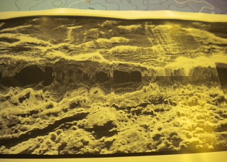
This TOBI image shows new volcanoes as pale areas,
and some darker areas are older seafloor.
Nick, we know that you have travelled from Texas to join this expedition - why? I have been studying The Cayman Trough for about 2 years, but using old data, so this is an amazing opportunity to update the data I am working with. Also, it is great to work with the team from NOC, to see how they operate and collaborate.
Nick, what is so special about the Mid-Cayman Spreading Centre (MCSC)? The Mid-Cayman Spreading Centre is unusual in the sense that it behaves much like some mid-ocean ridges, but is only about 80-100 km long. It has become one of the first recognised micro-plate boundaries and has not been surveyed for a number of years.
At plates one of two things happen: either molten rock forms volcanoes, or the crust just breaks along the fault line. We are still trying to understand why this happens. But now, we see places where these are combined, so we are trying to understand what makes one or the other.
The MCSC is connected to a group of faults that allow the Caribbean plate to move relative to the North America plate. It has some of the deepest seafloor in a ridge setting, up to 6500m in places. The deep sea floor is generally explained by the idea that the Cayman mantle is very cold and dense. But this does not explain the large mountains. The cause of these mountains is one of the problems we are hoping to solve on this expedition.
Nick, what does this mean for hunting for vents? Hydrothermal vents are nature's most dramatic expression of cooling of the crust. The movement of fluids carries heat as magma cools into rock, and these fluids are expelled at the ridge surface. Along their way, the fluids react chemically with the rocks they pass through. The heat and chemicals in the fluids ultimately lead to the kind of biological communities that we are hoping to discover and study on the MCSC.