Friday 21st January
Today's contributor: Jon Copley
Today we've been surveying Hook Ridge with the ship's multibeam sonar system, which produces high-resolution maps of the seafloor.
Although it is possible to use satellites to produce global maps of the ocean floor, satellite maps are only estimates of the underwater landscape, and don't show features smaller than a few miles across (two years ago, for example, we discovered a crater two-and-a-half miles across and a mile deep, which wasn't on any satellite maps). So for detailed maps of most of our planet, there is still no substitute for making measurements from ships using sonar.
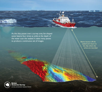
Mapping the seafloor with multibeam sonar
(schematic by British Antarctic Survey)
As a result, even in the 21st century, we still do not have a complete detailed map of two-thirds of our own planet. And detailed maps are vital for understanding what is happening on the seafloor - they reveal the geological processes taking place down there that ultimately shape our world, and provide the starting point for all our other deep-sea work.
In the afternoon, we continued our tracking of vent plumes using the CTD probe, hopefully narrowing down where the vents may be below us, in preparation for sending down our camera system.